For the American contribution to the human journey to the beginning of space and time
Space news (Space economics: American contributions; NASA’s 2018 budget) NASA’s released documents covering American economic contributions, future strategic plans, and current performance during this phase of the human journey to the beginning of space and time. Below you’ll find links to each.
The United States isa leader during the human journey to the beginning of space and time and 2018’s shaping up to be an exciting year. Curiosity will continue to travel across the Red Planet searchingfor signs of water and life, while NASA continues with plans for humans to stand upon Mars sometime in 2030s.
Check out NASA’s 2018 budget and strategic plans to spend the money invested in our desire to reach the stars and the vast beyond. America’s spending a lot of your moneyto expandthespace frontier each year. You might want to check out their progress and work. It couldbe important for the future of your kids and generations of human beings to come.
Follow the human journey to the beginning of space and time at NASA.
Next stop the ocean worlds of Enceladus and Europa
This illustration shows Cassini diving through the Enceladus plume in 2015. New ocean world discoveries from Cassini and Hubble will help inform future exploration and the broader search for life beyond Earth. Credits: NASA/JPL-Caltech
Space news (planetary science: water worlds of the solar system; Enceladus and Europa) –planets and moons around the solar system and exoplanets across the universe covered with water–
This graphic illustrates how scientists on NASA’s Cassini mission think water interacts with rock at the bottom of the ocean of Saturn’s icy moon Enceladus, producing hydrogen gas (H2). The Cassini spacecraft detected the hydrogen in the plume of gas and icy material spraying from Enceladus during its deepest and last dive through the plume on Oct. 28, 2015. Cassini also sampled the plume’s composition during previous flybys, earlier in the mission. From these observations, scientists have determined that nearly 98 percent of the gas in the plume is water vapor, about 1 percent is hydrogen, and the rest is a mixture of other molecules including carbon dioxide, methane, and ammonia. The graphic shows water from the ocean circulating through the seafloor, where it is heated and interacts chemically with the rock. This warm water, laden with minerals and dissolved gasses (including hydrogen and possibly methane) then pours into the ocean creating chimney-like vents. The hydrogen measurements were made using Cassini’s Ion and Neutral Mass Spectrometer, or INMS, instrument, which sniffs gasses to determine their composition. The finding is an independent line of evidence that hydrothermal activity is taking place in the Enceladus ocean. Previous results from Cassini’s Cosmic Dust Analyzer instrument, published in March 2015, suggested hot water is interacting with rock beneath the ocean; the new findings support that conclusion and indicate that the rock is reduced in its geochemistry. With the discovery of hydrogen gas, scientists can now conclude that there is a source of chemical free energy in Enceladus’ ocean. The Cassini mission is a cooperative project of NASA, ESA (the European Space Agency) and the Italian Space Agency. The Jet Propulsion Laboratory, a division of Caltech in Pasadena, manages the mission for NASA’s Science Mission Directorate, Washington. The Cassini orbiter and its two onboard cameras were designed, developed and assembled at JPL. The Ion and Neutral Mass Spectrometer was designed and built by NASA Goddard Space Flight Center, Greenbelt, Maryland; the team is based at Southwest Research Institute (SwRI) in San Antonio. For more information about the Cassini mission, visit http://www.nasa.gov/cassini and http://saturn.jpl.nasa.gov. Image Credit: NASA.
The solar system’s awash in water! NASA missions have provided verifiable facts showing ocean worlds and moons exist in our solar system and beyond,other than Earth. Planetary bodieswhere water is locked in a frozen embrace and even flowing beneath miles of ice. Liquid water exobiologists are keen to explore for life forms they would love to meet and get to know a little better during the next phase of the human journey to the beginning of space and time. Watch this YouTube video on NASA’s search for life on the ocean worlds of the solar system.
Best Evidence Yet for Reoccurring Water Vapor Plumes Erupting from Jupiter’s Moon When Galileo discovered Jupiter’s moon Europa in 1610, along with three other satellites whirling around the giant planet, he could have barely imagined it was such a world of wonder. This revelation didn’t happen until 1979 when NASA’s Voyager 1 and 2 flew by Jupiter and found evidence that Europa’s interior, encapsulated under a crust of ice, has been kept warm over billions of years. The warmer temperature is due to gravitational tidal forces that flex the moon’s interior — like squeezing a rubber ball — keeping it warm. At the time, one mission scientist even speculated that the Voyagers might catch a snapshot of geysers on Europa. Such activity turned out to be so elusive that astronomers had to wait over three decades for the peering eye of Hubble to monitor the moon for signs of venting activity. A newly discovered plume seen towering 62 miles above the surface in 2016 is at precisely the same location as a similar plume seen on the moon two years earlier by Hubble. These observations bolster evidence that the plumes are a real phenomenon, flaring up intermittently in the same region on the satellite. The location of the plumes corresponds to the position of an unusually warm spot on the moon’s icy crust, as measured in the late 1990s by NASA’s Galileo spacecraft. Researchers speculate that this might be circumstantial evidence for material venting from the moon’s subsurface. The material could be associated with the global ocean that is believed to be present beneath the frozen crust. The plumes offer an opportunity to sample what might be in the ocean, in the search for life on that distant moon. Credits: NASA/JPL
Papers published bythe journal Science and written by Cassini mission scientists and researchers working with the Hubble Space Telescope indicate hydrogen gas believed pouring from the subsurface ocean of Enceladus could potentially provide chemical energy life could use to survive and evolve. Watch this YouTube videocalled “NASA: Ingredients for Life at Saturn’s moon Enceladus“, itshowsthe proof scientists used to come to these conclusions. Their work provides new insights concerning possible oceans of water on moons of Jupiter and Saturn and other ocean moons in the solar system and beyond.
Best Evidence Yet for Reoccurring Water Vapor Plumes Erupting from Jupiter’s Moon When Galileo discovered Jupiter’s moon Europa in 1610, along with three other satellites whirling around the giant planet, he could have barely imagined it was such a world of wonder. This revelation didn’t happen until 1979 when NASA’s Voyager 1 and 2 flew by Jupiter and found evidence that Europa’s interior, encapsulated under a crust of ice, has been kept warm over billions of years. The warmer temperature is due to gravitational tidal forces that flex the moon’s interior — like squeezing a rubber ball — keeping it warm. At the time, one mission scientist even speculated that the Voyagers might catch a snapshot of geysers on Europa. Such activity turned out to be so elusive that astronomers had to wait over three decades for the peering eye of Hubble to monitor the moon for signs of venting activity. A newly discovered plume seen towering 62 miles above the surface in 2016 is at precisely the same location as a similar plume seen on the moon two years earlier by Hubble. These observations bolster evidence that the plumes are a real phenomenon, flaring up intermittently in the same region on the satellite. The location of the plumes corresponds to the position of an unusually warm spot on the moon’s icy crust, as measured in the late 1990s by NASA’s Galileo spacecraft. Researchers speculate that this might be circumstantial evidence for material venting from the moon’s subsurface. The material could be associated with the global ocean that is believed to be present beneath the frozen crust. The plumes offer an opportunity to sample what might be in the ocean, in the search for life on that distant moon. Credits: NASA/JPL
“This is the closest we’ve come, so far, to identifying a place with some of the ingredients needed for a habitable environment,” said Thomas Zurbuchen, associate administrator for NASA’s Science Mission Directorate at Headquarters in Washington. ”These results demonstrate the interconnected nature of NASA’s science missions that are getting us closer to answering whether we are indeed alone or not.”
Portrait of Thomas Zurbuchen taken on Monday, October 17, 2016, at NASA Headquarters in Washington. Photo Credit: (NASA/Aubrey Gemignani)
Researchers believe they have found evidence indicating hydrogen gas could be pouring out of hydrothermal vents on the floor of Saturn’s moon Enceladus and into these oceans of water. Any microbes existing in these distant waters could use this gas as a form of chemical energy to operate biological processes. By combining hydrogen with carbon dioxide dissolved in this ocean of water in a chemical reaction called methanogenesis, geochemists think methane could be produced which could act as the basis of a tree of life similar to the one observed on Earth.
Dramatic plumes, both large and small, spray water ice and vapor from many locations along the famed “tiger stripes” near the south pole of Saturn’s moon Enceladus. The tiger stripes are four prominent, approximately 84-mile- (135-kilometer-) long fractures that cross the moon’s south polar terrain. This two-image mosaic is one of the highest resolution views acquired by Cassini during its imaging survey of the geyser basin capping the southern hemisphere of Saturn’s moon Enceladus. It clearly shows the curvilinear arrangement of geysers, erupting from the fractures. .From left to right, the fractures are Alexandria, Cairo, Baghdad, and Damascus. As a result of this survey, 101 geysers were discovered: 100 have been located on one of the tiger stripes (PIA17188), and the three-dimensional configurations of 98 of these geysers have also been determined (PIA17186). The source location of the remaining geyser could not be definitively established. These results, together with those of other Cassini instruments, now strongly suggest that the geysers have their origins in the sea known to exist beneath the ice underlying the south polar terrain. These findings from the imaging survey, of which the two images composing this mosaic are a part, were presented in a paper by Porco, DiNino, and Nimmo and published in the online version of the Astronomical Journal in July 2014: http://dx.doi.org/10.1088/0004-6256/148/3/45. A companion paper, by Nimmo et al., is available at http://dx.doi.org/10.1088/0004-6256/148/3/46. The Cassini-Huygens mission is a cooperative project of NASA, the European Space Agency, and the Italian Space Agency. NASA’s Jet Propulsion Laboratory, a division of the California Institute of Technology in Pasadena, manages the mission for NASA’s Science Mission Directorate, Washington. The Cassini orbiter and its two onboard cameras were designed, developed and assembled at JPL. The imaging operations center is based at the Space Science Institute in Boulder, Colo. For more information about the Cassini-Huygens mission visit http://saturn.jpl.nasa.gov and http://www.nasa.gov/cassini. The Cassini imaging team homepage is at http://ciclops.org. Photojournal notes: This image has been rotated 180 degrees from its original orientation published on February 2, 2010. Image Credit: NASA/JPL/Space Science Institute
On Earth, this process is thought to be at the root of the tree of life, and could even be essential, critical to the origin of life on our little blue dot. Life existing on our planet requires three main ingredients, liquid water, a source of energy for metabolic processes, and specific chemical ingredients to develop and continue to thrive. This study shows Enceladus could have the right ingredients for life to exist, but planetary scientists and exobiologists are looking for evidence of the presence of sulfur and phosphorus.
This set of images from NASA’s Cassini mission shows how the gravitational pull of Saturn affects the amount of spray coming from jets at the active moon Enceladus. Enceladus has the most spray when it is farthest away from Saturn in its orbit (inset image on the left) and the least spray when it is closest to Saturn (inset image on the right). Water ice and organic particles gush out of fissures known as “tiger stripes” at Enceladus’ south pole. Scientists think the fissures are squeezed shut when the moon is feeling the greatest force of Saturn’s gravity. They theorize the reduction of that gravity allows the fissures to open and release the spray. Enceladus’ orbit is slightly closer to Saturn on one side than the other. A simplified version of that orbit is shown as a white oval. Scientists correlate the brightness of the Enceladus plume to the amount of solid material being ejected because the fine grains of water ice in the plume are very bright when lit from behind. Between the dimmest and brightest images, they detected a change of about three to four times in brightness, approximately the same as moving from a dim hallway to a brightly lit office. This analysis is the first clear finding that shows the jets at Enceladus vary in a predictable manner. The background image is a mosaic made from data obtained by Cassini’s imaging science subsystem in 2006. The inset image on the left was obtained on Oct. 1, 2011. The inset image on the right was obtained on Jan. 30, 2011. A related image, PIA17039, shows just the Enceladus images. The Saturn system mosaic was created from data obtained by Cassini’s imaging cameras in 2006. The Cassini-Huygens mission is a cooperative project of NASA, the European Space Agency, and the Italian Space Agency. NASA’s Jet Propulsion Laboratory, a division of the California Institute of Technology in Pasadena, manages the mission for NASA’s Science Mission Directorate, Washington, DC. The Cassini orbiter was designed, developed and assembled at JPL. The visual and infrared mapping spectrometer was built by JPL, with a major contribution by the Italian Space Agency. The visual and infrared mapping spectrometer science team is based at the University of Arizona, Tucson. For more information about the Cassini-Huygens mission, visit http://www.nasa.gov/cassini and http://saturn.jpl.nasa.gov/. Image Credit: NASA/JPL-Caltech/University of Arizona/Cornell/SSI
Previous data shows the rocky core of this moon is similar to meteorites containing these two elements, so they’re thought to be chemically similar in nature, and scientists are looking for the same chemical ingredients of life found on Earth, primarilycarbon, nitrogen, oxygen, and of course hydrogen, phosphorus, and sulphur.
Linda Spilker Cassini Project Scientist. Credits: NASA
“Confirmation that the chemical energy for life exists within the ocean of a small moon of Saturn is an important milestone in our search for habitable worlds beyond Earth,” said Linda Spilker, Cassini project scientist at NASA’s Jet Propulsion Laboratory (JPL) in Pasadena, California.
This illustration shows NASA’s Cassini spacecraft about to make one of its dives between Saturn and its innermost rings as part of the mission’s grand finale. Cassini will make 22 orbits that swoop between the rings and the planet before ending its mission on Sept. 15, 2017, with a final plunge into Saturn. The mission team hopes to gain powerful insights into the planet’s internal structure and the origins of the rings, obtain the first-ever sampling of Saturn’s atmosphere and particles coming from the main rings, and capture the closest-ever views of Saturn’s clouds and inner rings. During its time at Saturn, Cassini has made numerous dramatic discoveries, including a global ocean that showed indications of hydrothermal activity within the icy moon Enceladus, and liquid methane seas on its moon Titan. The Cassini mission is a cooperative project of NASA, ESA (the European Space Agency) and the Italian Space Agency. The Jet Propulsion Laboratory, a division of the California Institute of Technology in Pasadena, manages the mission for NASA’s Science Mission Directorate, Washington. For more information about the Cassini-Huygens mission, visit http://www.nasa.gov/cassini and http://saturn.jpl.nasa.gov. Image Credit: NASA/JPL-Caltech
Cassini detected hydrogen in plumes of gas and frozen matter spewing from Enceladus during the spacecraft’s deepest pass over its surface on October 28, 2015. This combined with previous data obtained by Cassini’s Ion and Neutral Mass Spectrometer (INMS) during earlier flybys around 2005,helped scientists determine that nearly 98 percent of the material spraying from the surface of the moon is water. The remaining two percent is thought to be around 1 percent hydrogen with some carbon dioxide, methane,ammonia and assorted unknown molecules in the mix.
Cassini has shown us two independent detections of possible water spewing from the surface of Enceladus. NASA and its partners are currently looking over proposals to send spacecraft to determineif there is an ocean of water beneath its surface by taking a sample. The Europa Life Finder (ELF)is the proposal NASA’s seriously looking at undertaking at this point, but reports indicate a few other proposals are also being discussed.We’ll provide additional information on other proposals as they’re released to media outlets.
“Although we can’t detect life, we’ve found that there’s a food source there for it. It would be like a candy store for microbes,” said Hunter Waite, lead author of the Cassini study.
Two different observations of possible plumes of water spraying from the icy surface of Saturn’s moon Enceladus provides proof hydrothermal activity is occurring beneath. Geophysicists believe hot water is combining chemically with rock and other matter at the bottom of an ocean of water underneath its icy surface to produce hydrogen gas. Hydrogen gas exobiologists think could be used as energy, food of a sort, to sustain life forms exobiologists want to meet and learn more about. A meeting that would change our place in the cosmos, the way we think about the universe, and reality.
Looking for an interplanetary vacation destination? Consider a visit to Europa, one of the Solar System’s most tantalizing moons. Ice-covered Europa follows an elliptical path in its 85-hour orbit around our ruling gas giant Jupiter. Heat generated from strong tidal flexing by Jupiter’s gravity keeps Europa’s salty subsurface ocean liquid all year round. That also means even in the absence of sunlight Europa has energy that could support simple life forms. Unfortunately, it is currently not possible to make reservations at restaurants on Europa, where you might enjoy a dish of the local extreme shrimp. But you can always choose another destination from Visions of the Future.
Astronomers and researchers working with the Hubble Space Telescope in 2016 reported on an observation of a possible plume erupting from the icy surface of Europa in the same general location Hubble observed a possible plume in 2014. This location also corresponds to the unusually warm region with cracks in the icy surface observed by NASA’s Galileo spacecraft back in the 1990s.This provides evidence this phenomenon could be periodic, intermittent in this region of the moon. Mission planners are looking at this region as a possible location to obtain a sample ofwater erupting from a possible ocean of water beneath its icy surface. Watch this video on Europa.
Estimates of the sizeof this most recently observed plume indicate it rose about 62 miles (~100 kilometers) from the surface of Europa, while the plume in 2014 only reached a height of around 30 miles (50 kilometers).
William Sparks Space Telescope Science Institute. Credits: Space Science Institute/NASA/JPL
“The plumes on Enceladus are associated with hotter regions, so after Hubble imaged this new plume-like feature on Europa, we looked at that location on the Galileo thermal map. We discovered that Europa’s plume candidate is sitting right on the thermal anomaly,” said William Sparks of the Space Telescope Science Institute in Baltimore, Maryland. Sparks led the Hubble plume studies in both 2014 and 2016.
One interesting thought’s the plumes and the hot spot is somehow linked. If this is the case, it could mean the vented water’s falling onto the surface of the moon, which would change the structure and chemistry of the surface grains and allow them to retain heat longer than the surrounding region. This location would be a great place to search for the ingredients of life and a possible entry point into an ocean of water beneath.
NASA’s Europa Clipper mission is being designed to fly by the icy Jovian moon multiple times and investigate whether it possesses the ingredients necessary for life. Credits: NASA/JPL-Caltech/SETI Institute
These observations by the Hubble Space Telescope and future looks enable future space missions to Europa and other ocean worlds in the solar system. Specifically, laying the groundwork for NASA’s Europa Clipper mission, which is setfor a launch sometime in the 2020s.
James Green: Director of Planetary Science, NASA Headquarters. Credits: NASA
“If there are plumes on Europa, as we now strongly suspect, with the Europa Clipper we will be ready for them,” said Jim Green, Director of Planetary Science, at NASA Headquarters.
NASA has indicated they’re looking to identify a possible site with persistent, intermittent plume activity as a target location for a mission to Europa to explore using its powerful suite of science instruments. Another team’s currently at work on a powerful ultraviolet camera to add to the Europa Clipper that would offer data similar to that provided by the Hubble Space Telescope, while some members of the Cassini team areworking on a very sensitive, next generation INMS instrument to put on the spacecraft.
Water’s the story of life on Earth! Science has shown it played and plays the main part in the birth,evolution, and sustenance of life on Earth.
NASA’s planning on taking the human journey to the beginning of space and time to the ocean worlds of the solar system during the decades ahead. To search for the ingredients of life and even possibly simple one-celled life forms, of an unknown type. We plan on going along for the ride to have a look for ourselves and we hope to see your name on the ship manifest. We’ll save a seat for you.
Join the human journey to the beginning of space and time by taking part in NASA’s Backyard Worlds: Planet 9. Participants take part in the search for hidden worlds between Neptune and Proxima Centauri.
This artist’s rendering shows NASA’s Europa mission spacecraft, which is being developed for a launch sometime in the 2020s. This view shows the spacecraft configuration, which could change before launch, as of early 2016. The mission would place a spacecraft in orbit around Jupiter in order to perform a detailed investigation of the giant planet’s moon Europa — a world that shows strong evidence for an ocean of liquid water beneath its icy crust and which could host conditions favorable for life. The highly capable, radiation-tolerant spacecraft would enter into a long, looping orbit around Jupiter to perform repeated close flybys of Europa. The concept image shows two large solar arrays extending from the sides of the spacecraft, to which the mission’s ice-penetrating radar antennas are attached. A saucer-shaped high-gain antenna is also side mounted, with a magnetometer boom placed next to it. On the forward end of the spacecraft (at left in this view) is a remote-sensing palette, which houses the rest of the science instrument payload. The nominal mission would perform at least 45 flybys of Europa at altitudes varying from 1,700 miles to 16 miles (2,700 kilometers to 25 kilometers) above the surface. This view takes artistic liberty with Jupiter’s position in the sky relative to Europa and the spacecraft. Credits: NASA/JPL/ESA
Space news (The search for life beyond Earth) – An artist’s rendition of the Europa spacecraft orbiting Jupiter–
This 12-frame mosaic provides the highest resolution view ever obtained of the side of Jupiter’s moon Europa that faces the giant planet. It was obtained on Nov. 25, 1999 by the camera onboard the Galileo spacecraft, a past NASA mission to Jupiter and its moons which ended in 2003. NASA will announce today, Tuesday, May 26, the selection of science instruments for a mission to Europa, to investigate whether it could harbor conditions suitable for life. The Europa mission would conduct repeated close flybys of the small moon during a three-year period. Numerous linear features in the center of this mosaic and toward the poles may have formed in response to tides strong enough to fracture Europa’s icy surface. Some of these features extend for over 1,500 kilometers (900 miles). Darker regions near the equator on the eastern (right) and western (left) limb may be vast areas of chaotic terrain. Bright white spots near the western limb are the ejecta blankets of young impact craters. North is to the top of the picture and the sun illuminates the surface from the left. The image, centered at 0 latitude and 10 longitude, covers an area approximately 2,500 by 3,000 kilometers. The finest details that can discerned in this picture are about 2 kilometers across (about 1,550 by 1,860 miles). The images were taken by Galileo’s camera when the spacecraft was 94,000 kilometers (58,000 miles) from Europa. Image Credit: NASA/JPL/University of Arizona
NASA’s Jet Propulsion Laboratory released this artist‘s rendering of the Europa spacecraft, which is set to head to Jupiter sometime in the 2020s. The Europa Mission spacecraftconfiguration in early 2016 is shown in this image. The final spacecraft configuration at launch could easily be different, so stay tuned here for more news. The position of Jupiter in the sky relative to Europa and the spacecraftare also off in this drawing.
This is an artist’s concept of a plume of water vapor thought to be ejected off the frigid, icy surface of the Jovian moon Europa, located about 500 million miles (800 million kilometers) from the sun. Spectroscopic measurements from NASA’s Hubble Space Telescope led scientists to calculate that the plume rises to an altitude of 125 miles (201 kilometers) and then it probably rains frost back onto the moon’s surface. Previous findings already pointed to a subsurface ocean under Europa’s icy crust. Image credit: NASA/ESA/K. Retherford/SWRI
Two large solar arrays are shown extending from the sides of the Europa spacecraft to which the ice-penetrating radar antennas are attached in this artist’s rendition. On the side of the craft, a saucer-shaped high gain antenna is depicted next to a magnetometer boom. On the forward section is a remote-sensing palette with the remaining science instruments.
Jupiter’s moon Europa has a crust made up of blocks, which are thought to have broken apart and ‘rafted’ into new positions, as shown in the image on the left. These features are the best geologic evidence to date that Europa may have had a subsurface ocean at some time in its past. Combined with the geologic data, the presence of a magnetic field leads scientists to believe an ocean is most likely present at Europa today. In this false color image, reddish-brown areas represent non-ice material resulting from geologic activity. White areas are rays of material ejected during the formation of the Pwyll impact crater. Icy plains are shown in blue tones to distinguish possibly coarse-grained ice (dark blue) from fine-grained ice (light blue). Long, dark lines are ridges and fractures in the crust, some of which are more than 1,850 miles long. These images were obtained by NASA’s Galileo spacecraft during Sept. 7, 1996, Dec. 1996 and Feb. 1997 at a distance of 417,489 miles. Image Credit: NASA/JPL/University of Arizona
The Europa Mission profile has a very capable, radiation-resistant spacecraft traveling to Jupiter, where it enters into a long, looping orbit of the giant planet in order to perform at least 45 repeated flybys of Europa at altitudes ranging from 1700 miles to 16 miles (2700 kilometers to 25 kilometers) above its surface. Planetary scientists want to take a closer look at the evidence for an ocean of liquid water beneath its icy shell. An ocean of liquid water that could be the habitat of alien lifeforms we want to get to know better.
One of the oldest regions of the Red Planet discovered, an ancient Martian lake, or the site of an ancient hot spring first explored by NASA’s Spirit rover
NASA’s Mars 2020 rover’s expected to land at one of the three sites noted on this image of the Red Planet. Credits: NASA
Space news (The Journey to Mars: Mars 2020; possible landing sites) – Northeast Syrtis: Jerero crater; or Columbia Hills, on the Red Planet –
Planetary scientists and other scientists attending the third landing site workshop hosted by NASA in order to determine the best place for its Mars 2020 rover to land recommend three places. NASA’s been using the Mars Reconnaissance Orbiter to search for suitable sites since about 2006 and to help in the identification, study, and verification of possible future landing sites for coming manned missions during most recent history. Data and observations provided by the MRO also helped participants narrow down the choices to three during the workshop.
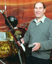
Dr. Matt Golombek, just one of the rocket geniuses working at NASA’s Jet Propulsion Laboratory. Credits: NASA/JPL
“From the point of view of evaluating potential landing sites, the Mars Reconnaissance Orbiter is the perfect spacecraft for getting all the information needed,” said the workshop’s co-chair, Matt Golombek of NASA’s Jet Propulsion Laboratory, Pasadena, California. “You just can’t overstate the importance of MRO for landing-site selection.”
Leslie Tamppari, another genius working at NASA’s Jet Propulsion Laboratory. Credits: NASA/JPL
“Missions on the surface of Mars give you the close-up view, but what you see depends on where you land. MRO searches the globe for the best sites,” said MRO Deputy Project Scientist Leslie Tamppari of JPL.
NASA’s Jet Propulsion is famous for employing the experience, skills, and knowledge of geniuses, but this is getting to be ridiculous. Credits: NASA/JPL
“Whether it is looking at the surface, the subsurface or the atmosphere of the planet, MRO has viewed Mars from orbit with unprecedented spatial resolution, and that produces huge volumes of data,” said MRO Project Scientist Rich Zurek of JPL.“These data are a treasure trove for the whole Mars scientific community to study as we seek to answer a broad range of questions about the evolving habitability, geology, and climate of Mars.”
The Journey to the Red Planet
The human journey to the beginning of space and time will be making a stop on Mars sometime in the 2030s if everything goes as planned with NASA’s Journey to Mars. Mars 2020 is expected to launch aboard the Atlas V 541 rocket from Space Launch Complex 41 at Cape Canaveral Air Force Station in Florida around July 2020. After a journey of millions of miles across the solar system to the Red Planet, the Mars 2020 rover will land at one of three possible sites.
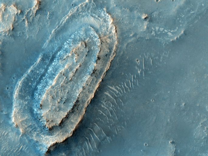
Northeast Syrtis
NASA’s Mars 2020 rover could be landing here to look for evidence one-celled life flourished in water accumulated on the surface of the Red Planet. Credits: NASA/MRO/HIRISE
Images of the first possible landing site in the Northeast part of Syrtis Major showEarly Noachian bedrock planetary scientists would like to have a closer look at for signs of possible life. An excellent place for study and exploration of the past of the Red Planet, scientists are currently studying whether it’s safe for Mars 2020 to land. There could be too many boulders or even steep slopes unidentified in the initial analysis of images of this region making landing problematic at best. There’s also always the possibility of something we haven’t thought of. If the site is safe, it will be considered for the final choice, and possibly even for the rovers planned by Europe and NASA sometime around 2018.
This part of the Red Planet was once warmed by volcanoes, so planetary scientists want to look for ancient hot springs and even surface ice melt where liquid water could have flowed. Liquid water’s one of the catalysts-of-life planetary scientists look for in the search for extraterrestrial life. The layered terrain of Northeast Syrtis could hold a record of ancient simple life forms that existed on Mars during its early history. At the very least it should tell us more about interactions between water and minerals over successive parts of the Red Planet when it was young. This site we should definitely take a look at.
Jezero Crater
NASA scientists plan on using instruments on the Mars 2020 rover to look into the possibility simple, one-celled life could have evolved and flourished in the water of a lake they think existed on the surface of the Red Planet in this region. Credits: NASA/MRO/HIRISE
Rewind time 3.5 billion years in Jezero crater, to when river channels spilled over the crater wall and formed a lake. Planetary scientists see evidence water from this lake carried clay minerals from the lake bed after this body of water dried up. Scientists want to explore the crater for signs microbial life once lived here during events such as this when Jezero crater was a little wetter. For the remains of ancient life in the lakebed sediments.
Columbia Hills, Mars
Scientists think simple, one-celled life could have developed and flourished in the waters of a shallow lake they believe formed here billions of years ago. Credits: NASA/MRO/HIRISE
After additional study planetary scientists and geochemists agree mineral springs once bubbled up from the rocks of Columbia Hills in Gusev crater on the Red Planet. Originally, the Spirit rover found no clear signs water flowed over or existed in the rocks of this region of Mars, but the discovery hot springs once existed here has scientists thinking a shallow lake may have once formed for a time. Warm, inviting waters microbial life could have evolved in, exobiologists are keen to examinesoils and lakebed sediments of Gusev crater for their remains.
The Final Landing Site of the Mars 2020 rover
NASA’s shortlisted the possible landing sites to the three regions seen in the slideshow above. Credits: NASA/MRO/HIRISE
Possible landing sites of NASA’s Mars 2020 rover may change as the mission goes forward, the science mission and even engineering considerations of achieving their goals could change as they learn more. Ultimately, NASA will decide on a landing site with geology indicating a wetter past that also meets all criteria. Stay tuned to the human journey to the beginning of space and time during the months and years ahead to learn more.
To study ways to protect future astronauts as they prepare and one day travel to the other planets and throughout the solar system
Enter a captionVisual Impairment Intracranial Pressure (VIIP) Syndrome was identified in 2005. It is currently NASA’s leading spaceflight-related health risk and is more predominant among men than women in space. Here, NASA astronaut Karen Nyberg of NASA uses a fundoscope to image her eye while aboard the International Space Station.Credits: NASA
Space news (NASA initiatives: The Transitional Research Institute (NTRI); researching and developing innovative approaches to decrease risks for humans associated with traveling and living in space) – Texas Medical Center Innovation Institute in Houston, Texas –
Astronauts need to be tested and readied for space, a dangerous and hazardous environment for humans to work and live in. Credits: NASA
During the next few decades human beings will travel to parts of the solar system never visited before and the journey is expected to be dangerous, yet awe-inspiring. In order to reduce the risks associated with traveling and living in space, NASA has announced the formation of a partnership with Baylor College of Medicine in Houston. Plans are to operate a new institute charged with researching and developing innovative approaches designed to help keep astronauts alive and healthy during long-term voyages to Mars and beyond.
Men and women react differently to the environment called space and research can differ between the two. This diagram shows key differences between men and women in cardiovascular, immunologic, sensorimotor, musculoskeletal, and behavioral adaptations to human spaceflight. Credits: NASA
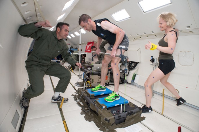
Astronauts need to be in shape to handle the rigors and hazards associated with living and traveling in space. Biomechanical Engineer Renita Fincke monitors Biomechanical Engineer Erin Caldwell as she performs a squat exercise to generate a computational biomechanical model in the Exercise Physiology and Counter Measures Project in Building 261. Photo Date: October 25, 2011.
Called the NASA Transitional Research Institute (NTRI), the new institute will implement a bench-to-spaceflight strategy. Their main goals to produce new treatments, countermeasures, and technologies with practical applications towards known spaceflight health risks. Medical problems like visual impairment intracranial pressure (VIIP) Syndrome, which was identified in 2005, and is currently NASA’s number one spaceflight-related health risk for astronauts. Plans are for the work to be done at the Texas Medical Center Innovation Institute in Houston, Texas.
Marshall Porterfield is the new director of NASA’s Space Life and Physical Sciences Research and Applications Division. He’ll be leading the charge to protect astronauts as they prepare to head to Mars. Credit: Linked
“It’s fitting on the 47th anniversary of humanity’s first moon landing that we’re announcing a new human spaceflight research institute that will help reduce risks for our astronauts on the next giant leap – our Journey to Mars,” said Marshall Porterfield, NASA’s director of Space Life and Physical Sciences Research and Applications.
Time to get to work
Astronauts will be happy to hear this news and it has the potential to enable mankind’s journey to Mars and beyond to the beginning of space and time. The NASA Transitional Research Institute willhelp form relationships between scientists and medical laboratories and institutes looking to reduce health risks and performance barriers for humans traveling and living in space. It will also keep astronauts healthier during their space missions during the decades ahead.
NASA and FEMA scientists tracking asteroid using ground and space-based telescopes to refine estimates
If this asteroid impacted on the Earth, it would be a dark, bad day for life on the planet. Image Credit: NASA
Space news Sept. 20, 2020 ( NASA Planetary Defense Office: joint NASA and FEMA operation; emergency response to future asteroid impact) – Jet Propulsion Laboratory in El Segundo, California; conducting emergencyresponse exercise forpossible future asteroid impact –
NASA Planetary Defense Officer Lindley Johnson was among speakers at Oct. 25, 2016, NASA/FEMA tabletop exercise in El Segundo, California, simulating an emergency response to a hypothetical future asteroid impact. Regular exercises like this facilitate a strong working relationship between the asteroid science community and emergency managers. Credits: The Aerospace Corporation.
NASA Planetary Defense Officer Lindley Johnson spoke today at a simulated emergency response exercise to a possible future asteroid impact estimated for some time around Sept. 20, 2020. The exercise provided a forum for the planetary science community to prepare emergency managers by collecting, analyzing, and sharing data about such an event should it occur. It also provided the chance for emergency response personnel, the asteroid science community, and emergency managers across the country and the world to begin forming the strong working relationshipsrequired to protect humanity from an asteroid strike.
This particular exercise wasthe third in a series hosted jointly by NASA and the Federal Emergency Management Agency (FEMA). It was conducted to prepare emergency services in the event of an asteroid impact becomes more likely during the years ahead and strengthen bonds between their partnership.At this point, NASA and FEMA officials say an asteroid impact is very unlikely, but we need to be ready in case of an emergency.
Representatives of NASA, FEMA, the Jet Propulsion Laboratory, the U.S. Department of Energy’s national laboratories, the U.S. Air Force, and the California Governor’s Office of Emergency Services gathered in El Segundo, California, on Oct. 25, 2016, for a tabletop exercise simulating a possible asteroid impact in 2020. The exercise provided a forum for the planetary science community to show emergency managers how it would collect, analyze and share data about such an event. Credits: The Aerospace Corporation
“It’s not a matter of if — but when — we will deal with such a situation,” said Thomas Zurbuchen, Associate Administrator for NASA’s Science Mission Directorate in Washington. “But unlike any other time in our history, we now have the ability to respond to an impact threat through continued observations, predictions, response planning, and mitigation.”
During the emergency response exercise, planetary science community representatives showed how data concerning a possible future asteroid impact would be collected, analyzed, and shared. Emergency response managers talked about the way the information would be used to consider the challenges and options during an asteroid impact. They also talked about the way to prepare, respond, and tell the public about the crisis.
Washington, DC, May 12, 2009 — FEMA Administrator W. Craig Fugate in the FEMA Studio. FEMA/Bill Koplitz Image Credits: Bill Koplitz/FEMA/NASA
“It is critical to exercise these kinds of low-probability but high-consequence disaster scenarios,” FEMA Administrator Craig Fugate said. “By working through our emergency response plans now, we will be better prepared if and when we need to respond to such an event.”
This possible asteroid impact in four years time was first discovered in the fall and was at that time estimated at 2 percent. NASA assets will continue to track the asteroid for the next three months, before updating the chances of a possible impact. But at this point, NASA and its partners are preparingto launch a possible mission to deflect or otherwise intercept the asteroid. Exercise attendees were left with the challenge of preparing for a mass evacuation of a major US metropolitan city and region in the worst case scenario. They went over possible impact scenarios, looked at possible population displacement estimates, discussed infrastructure that would be affected, and all data that could realistically be known concerning a possible asteroid impact in four years time.
“The high degree of initial uncertainty coupled with the relatively long impact warning time made this scenario unique and especially challenging for emergency managers,” said FEMA National Response Coordination Branch Chief Leviticus A. Lewis. “It’s quite different from preparing for an event with a much shorter timeline, such as a hurricane.”
They also looked at ways to pass on accurate, timely, and useful information to the general public, while still addressing the possible issue of false rumors and information emerging during the years leading up to an impact.
“These exercises are invaluable for those of us in the asteroid science community responsible for engaging with FEMA on this natural hazard,” said NASA Planetary Defense Officer Lindley Johnson. “We receive valuable feedback from emergency managers at these exercises about what information is critical for their decision making, and we take that into account when we exercise how we would provide information to FEMA about a predicted impact.”
Study and planning for a possible asteroid impact continues
NASA’s continuing to provide expert input to FEMA about the asteroid through the Planetary Coordination Office. The partners will continue to assess the asteroid and conduct asteroid impact exercises in preparation for a worst case scenario. They also intend to start reaching out to other representatives from local and state emergency management agencies and the private sector in future emergency exercises.
NASA’s looking for a few good firms and private individuals to form meaningful, useful business partnerships with, check it out here.
Electric-blue wisps of gas and young stars in early stages of star birth startle the senses in this stunning Hubble Space Telescope image. Credits: NASA/Hubble/ESA
Space news (astrophysics: stellar nurseries; HII region N159) – 180,000 light-years from Earth deep within the Large Magellanic Cloud (LMC) –
Nearly 200 000 light-years from Earth, the Large Magellanic Cloud, a satellite galaxy of the Milky Way, floats in space, in a long and slow dance around our galaxy. As the Milky Way’s gravity gently tugs on its neighbour’s gas clouds, they collapse to form new stars. In turn, these light up the gas clouds in a kaleidoscope of colours, visible in this image from the NASA/ESA Hubble Space Telescope.
The stunning Hubble Space Telescope image seen above shows the heart of a cosmic maelstrom, glowing gas, and dark dust deep within the Large Magellanic Cloud (LMC), one of many satellite galaxies of the Milky Way. This stormy region of space contains stellar nursery N159, an HII region over 150 light-years across with many hot young suns emitting intense ultraviolet radiation. Ultraviolet light causing nearby hydrogen gas to glow and torrential stellar winds carving ridges, arcs, and filaments out of surrounding gas and dust.
The Papillon Nebula is seen in the inset image in the top right of the main image of the Large Magellanic Cloud. Credit: M. Heydari-Malayeri(Paris Observatory) et al, WFPC2, HST, ESA, NASA
Early stages of star birth
Near the heart of this cosmic maelstrom lies the butterfly-shaped Papillon Nebula, a small, dense stellar object astronomers refer to as a High-Excitation Blob, they have linked to the early stages of the formation of a massive star. This region of space was first detected using Hubble Space Telescope’s Wide Field Planetary Camera 2 (WFPC2).
The Tarantula Nebula Image Credit & Copyright: Processing – Robert Gendler, Roberto Colombari Data – Hubble Tarantula Treasury, European Southern Observatory
Nebula N159’s just south of the Tarantula Nebula (heic 1402), a star-forming region also imaged by Hubble’s WFPC2. Hidden within this region of space astronomers found several massive stars they’re currently studying looking for clues to the growth and evolution of the most massive stars in the galaxy. The image seen here was taken using the Hubble Space Telescope’s Advanced Camera for Surveys.
In order to better understand intricate operations and detailed planning needed to capture multi-ton boulder from asteroid surface
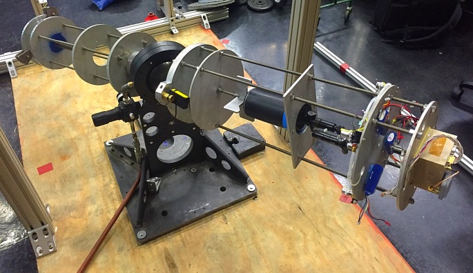
A prototype of the Asteroid Redirect Mission (ARM) robotic capture module system is tested with a mock asteroid boulder in its clutches at NASA’s Goddard Space Flight Center in Greenbelt, Maryland. The robotic portion of ARM is targeted for launch in 2021. Located in the center’s Robotic Operations Center, the mockup helps engineers understand the intricate operations required to collect a multi-ton boulder from an asteroid’s surface. The hardware involved here includes three space frame legs with footpads, two seven degrees of freedom arms that have with microspine gripper “hands” to grasp onto the boulder. NASA and students from West Virginia University built the asteroid mockup from rock, styrofoam, plywood and an aluminum endoskeleton. The mock boulder arrived in four pieces and was assembled inside the ROC to help visualize the engagement between the prototype system and a potential capture target. Inside the ROC, engineers can use industrial robots, a motion-based platform, and customized algorithms to create simulations of space operations for robotic spacecraft. The ROC also allows engineers to simulate robotic satellite-servicing operations, fine-tuning systems and controllers and optimizing performance factors for future missions when a robotic spacecraft might be deployed to repair or refuel a satellite in orbit. Image Credit: NASA
Space news (Asteroid Redirect Mission: testing of prototype of robotic capture module system) – The Robotic Operations Center of NASA’s Goddard Space Flight Center –
A new report provides expert findings from a special action team on how elements of the Asteroid Redirect Mission (ARM) can address decadal science objectives and help close Strategic Knowledge Gaps (SKGs) for future human missions in deep space. Credits: NASA/Goddard
Inside the Robotic Operations Center (ROC) of NASA’s Goddard Space Flight Center engineers are at work preparing the robotic section of the Asteroid Redirect Mission (ARM). The most recent work involved testing a prototype of the asteroid capture system with a mock boulderbuilt by NASA and students from West Virginia University. This work will help engineers learn more about the intricate operations needed to capture a multi-ton boulder from the surface of an asteroid. The robotic section of ARM is targeted for a 2021 launch window.
The capability built into the ROC allows engineers to create a simulation of the capture of a boulder from the surface of an asteroid. Here they can also simulate servicing of the satellite, fine tuning of systems and controllers, and even optimize all performance factors for future repairs and refueling. An important capabilitywhen building spacecraft worth hundreds of millions of dollars and even more. One that saves money and time.
The Asteroid Redirect Mission is expected to offer benefits that should teach us more about operating in space and enable future space missions. You can read a report here on some of the expected benefits.
The report reflects the findings of a two-month study conducted by members of the Small Bodies Assessment Group (SBAG). It explains many of ARM’s potential contributions to the future of the human journey to the beginning of space and time.
“This report is an important step in identifying ways that ARM will be more scientifically relevant as we continue mission formulation for the robotic and the crew segments,” said Gates. “We’re currently in the process of selecting hosted instruments and payloads for the robotic segment, and hope to receive an updated analysis from the SBAG after we announce those selections in spring 2017.”
During the same relative time period, other clues indicate more oxygen was present in the atmosphere thanfound currently
This image shows NASA’s Curiosity Mars rover at a location called “Windjana,” where the rover found rocks containing manganese oxide minerals, which require abundant water and strongly oxidizing conditions to form. In front of the rover are two holes from the rover’s sample-collection drill and several dark-toned features that have been cleared of dust (see inset images). These flat features are erosion-resistant fracture fills containing manganese oxides. The discovery of these materials suggests the Martian atmosphere might once have contained higher abundances of free oxygen than it does now. Credits: NASA/JPL-Caltech/MSSS
Space news (planetary science: Martian rocks containing manganese oxide minerals; indicating a wetter surface with more atmospheric oxygen than presently found on Mars) – Mars (the Red Planet), 154 million miles (249 kilometers) from Sol, or 141 million miles (228 million kilometers) from Earth, on average –
This view from the Mars Hand Lens Imager (MAHLI) on NASA’s Curiosity Mars Rover shows the rock target “Windjana” and its immediate surroundings after inspection of the site by the rover. The drilling of a test hole and a sample collection hole produced the mounds of drill cuttings that are markedly less red than the other visible surfaces. This is material that the drill pulled up from the interior of the rock. This view is from the 627th Martian day, or sol, of Curiosity’s work on Mars (May 12, 2014). The open hole from sample collection is 0.63 inch (1.6 centimeters) in diameter. It was drilled on Sol 621 (May 5, 2014). A preparatory “mini drill” hole, to lower right from the open hole, was drilled on Sol 615 (April 29, 2014) and subsequently filled in with cuttings from the sample-collection drilling. Two small patches ofless red color to the right of the drill holes are targets “Stephen” (higher) and “Neil,” where multiple laser hits by Curiosity’s Chemistry and Camera (ChemCam) instrument blasted some of the reddish surface dust off the surface of the rock. The vigorous activity of penetrating the rock with the rover’s hammering drill also resulted in slides of loose material near the rock. MAHLI was built by Malin Space Science Systems, San Diego. NASA’s Jet Propulsion Laboratory, a division of the California Institute of Technology in Pasadena, manages the Mars Science Laboratory Project for the NASA Science Mission Directorate, Washington. JPL designed and built the project’s Curiosity rover. Credit: NASA/JPL-Caltech/MSSS
NASA’s Curiosity Mars rover has found rocks at a place called Windjana containing manganese oxide minerals according to reports from planetary scientists studying samples from the region. On Earth rocks of this type formed during the distant past in the presence of abundant water and atmospheric oxygen. This news added to previous reports of ancient lakes and other groundwater sources during Mar’s pastpoints to a wetter environment in the study region Gale Crater during this time.
This image from the Navigation Camera (Navcam) on NASA’s Curiosity Mars rover shows a sandstone slab on which the rover team has selected a target, “Windjana,” for close-up examination and possible drilling. The target is on the approximately 2-foot-wide (60-centimeter-wide) rock seen in the right half of this view. The Navcam’s left-eye camera took this image during the 609th Martian day, or sol, of Curiosity’s work on Mars (April 23, 2014). The rover’s name is written on the covering for a portion of the robotic arm, here seen stowed at the front of the vehicle. The sandstone target’s informal name comes from Windjana Gorge in Western Australia. If this target meets criteria set by engineers and scientists, it could become the mission’s third drilled rock and the first that is not mudstone. The rock is within a waypoint location called “the Kimberley,” where sandstone outcrops with differing resistance to wind erosion result in a stair-step pattern of layers. Windjana is within what the team calls the area’s “middle unit,” because it is intermediate between rocks that form buttes in the area and lower-lying rocks that show a pattern of striations. NASA’s Jet Propulsion Laboratory, a division of the California Institute of Technology, Pasadena, manages the Mars Science Laboratory Project for NASA’s Science Mission Directorate, Washington. JPL designed and built the project’s Curiosity rover and the rover’s Navcam. Image Credit: NASA/JPL-Caltech
Planetary scientists used the laser-firing instrument on the Curiosity Mars rover to detect high levels of manganese-oxide in mineral veins found at Windjana. “The only ways on Earth that we know how to make these manganese materials involve atmospheric oxygen or microbes,” said Nina Lanza, a planetary scientist at Los Alamos National Laboratory in New Mexico. “Now we’re seeing manganese oxides on Mars, and we’re wondering how the heck these could have formed?”
On this view of the Curiosity rover mission’s waypoint called “the Kimberley,” the red dot indicates the location of a sandstone target, “Windjana,” that researchers selected for close-up inspection and possibly for drilling. The view is an excerpt from an April 11, 2014, observation by the High-Resolution Imaging Science Experiment (HiRISE) camera on NASA’s Mars Reconnaissance Orbiter. In the image’s enhanced color, Curiosity itself appears as the bright blue object at the two-o’clock position relative to the butte in the lower center of the scene. Thatbutte is called “Mount Remarkable” and stands about 16 feet (5 meters) high. The rover subsequently drove to within its robotic arm’s reach of Windjana. For scale, the distance between the parallel wheel tracks visible in the image is about 9 feet (2.7 meters). In the area of the Kimberley waypoint, sandstone outcrops with differing resistance to wind erosion result in a stair-step pattern of layers. Windjana is within what the team calls the area’s “middle unit,” because it is intermediate between rocks that form buttes in the area and lower-lying rocks that show a pattern of striations. The exaggerated color, to make differences in Mars surface materials more apparent, makes Curiosity appear bluer than the rover really looks. HiRISE is one of six instruments on NASA’s Mars Reconnaissance Orbiter. The University of Arizona, Tucson, operates HiRISE, which was built by Ball Aerospace & Technologies Corp., Boulder, Colo. NASA’s Jet Propulsion Laboratory, a division of the California Institute of Technology in Pasadena, manages the Mars Reconnaissance Orbiter and Mars Science Laboratory projects for NASA’s Science Mission Directorate, Washington. JPL designed and built the Mars Science Laboratory Project’s Curiosity rover. Image Credit: NASA/JPL-Caltech/Univ. of Arizona
Planetary scientists are looking at other processes that could create the manganese-oxide they found in rocks in Mar’s Gale Crater region. Possible culprits at this point include microbes, but even optimistic planetary scientists are finding little fan fair accompanyingtheir ideas. Lanza said, “These high manganese materials can’t form without lots of liquid water and strongly oxidizing conditions. Here on Earth, we had lots of water but no widespread deposits of manganese oxides until after the oxygen levels in our atmosphere rose.”
NASA’s Curiosity Mars rover used the Mars Hand Lens Imager (MAHLI) instrument on its robotic arm to illuminate and record this nighttime view of the sandstone rock target “Windjana.” The rover had previously drilled a hole to collect sample material from the interior of the rock and then zapped a series of target points inside the hole with the laser of the rover’s Chemistry and Camera (ChemCam) instrument. The hole is 0.63 inch (1.6 centimeters) in diameter. The precision pointing of the laser that is mounted atop the rover’s remote-sensing mast is evident in the column of scars within the hole. That instrument provides information about the target’s composition by analysis of the sparks of plasma generated by the energy of the laser beam striking the target. Additional ChemCam laser scars are visible at upper right, on the surface of the rock. This view combines eight separate MAHLI exposures, taken at different focus settings to show the entire scene in focus. The exposures were taken after dark on the 628th Martian day, or sol, of Curiosity’s work on Mars (May 13, 2014). The rover drilled this hole on Sol 621 (May 5, 2014). MAHLI includes light-emitting diodes as well as a color camera. Using the instrument’s own lighting yields an image of the hole’s interior with less shadowing than would be seen in a sunlit image. The camera’s inspection of the interior of the hole provides documentation about what the drill bit passed through as it penetrated the rock — for example, to see if it cut through any mineral veins or visible layering. MAHLI was built by Malin Space Science Systems, San Diego. NASA’s Jet Propulsion Laboratory, a division of the California Institute of Technology in Pasadena, manages the Mars Science Laboratory Project for the NASA Science Mission Directorate, Washington. JPL designed and built the project’s Curiosity rover. Credit: NASA/JPL-Caltech/MSSS
Geologists have found high concentrations of manganese oxide minerals is an important marker of a major shift in Earth’s atmospheric composition, from relatively low oxygen levels during the distant past, to the oxygen-rich environment we live in today. Planetary scientists studying the rocks they found in Gale Crater suggest the presence of these materials indicates oxygen levels on Mars rose also, before declining to the present low levels detected. The question is how was Mar’s oxygen-rich atmosphere formed?
November 3, 2015 Planetary scientist Lanza at the summit of Hvannadalsnukur, the highest mountain in Iceland, practicing glacier travel techniques similar to those needed for exploring the farthest reaches of the planet and possibly the solar system. Credit: Los Alamos National Laboratory
“One potential way that oxygen could have gotten into the Martian atmosphere is from the breakdown of water when Mars was losing its magnetic field,” said Lanza. “It’s thought that at this time in Mars’ history, water was much more abundant. Yet without a protective magnetic field to shield the surface, ionizing radiation started splitting water molecules into hydrogen and oxygen. Because of Mars’ relatively low gravity, the planet wasn’t able to hold onto the very light hydrogen atoms, but the heavier oxygen atoms remained behind. Much of this oxygen went into rocks, leading to the rusty red dust that covers the surface today. While Mars’ famous red iron oxides require only a mildly oxidizing environment to form, manganese oxides require a strongly oxidizing environment, more so than previously known for Mars.“
Lanza added, “It’s hard to confirm whether this scenario for Martian atmospheric oxygen actually occurred. But it’s important to note that this idea represents a departure in our understanding for how planetary atmospheres might become oxygenated. Abundant atmospheric oxygen has been treated as a so-called biosignature or a sign of extant life, but this process does not require life.“
This image from the Navigation Camera (Navcam) on NASA’s Curiosity Mars rover shows two holes at top center drilled into a sandstone target called “Windjana.” The farther hole, with larger pile of tailings around it, is a full-depth sampling hole. It was created by the rover’s hammering drill while the drill collected rock-powder sample material from the interior of the rock. The nearer hole was created by a shallower test drilling into the rock in preparation for the sample collection. Each hole is 0.63 inch (1.6 centimeters) in diameter. The full-depth hole is about 2.6 inches (6.5 centimeters) deep, drilled during the 621st Martian day, or sol, of Curiosity’s work on Mars (May 5, 2014). The test hole is about 0.8 inch (2 centimeters) deep, drilled on Sol 615 (April 29, 2014). This image was taken on Sol 621 (May 5). The sandstone target’s informal name comes from Windjana Gorge in Western Australia. The rock is within a waypoint location called “The Kimberley,” where sandstone outcrops with differing resistance to wind erosion result in a stair-step pattern of layers. Windjana is within what the team calls the area’s “middle unit,” because it is intermediate between rocks that form buttes in the area and lower-lying rocks that show a pattern of striations. NASA’s Jet Propulsion Laboratory, a division of the California Institute of Technology, Pasadena, manages the Mars Science Laboratory Project for NASA’s Science Mission Directorate, Washington. JPL designed and built the project’s Curiosity rover and the rover’s Navcam. Credit: NASA/JPL-Caltech
The Curiosity rover has been investigating Gale Crater for around four years and recent evidence supports the possibilityconditions needed to form these deposits were present in other locations. The concentrations of manganese oxide discovered were found in mineral-filled cracks in sandstones in a region of the crater called “Kimberley”. NASA’s Opportunity rover has been exploring the surface of the planet since 2004 and recently reported similar high manganese deposits in a region thousands of miles away. Supporting the idea environments required to form similar deposits could be found well beyond Gale Crater.
NASA’s Curiosity Mars rover used the camera at the end of its arm in April and May 2014 to take dozens of component images combined into this self-portrait where the rover drilled into a sandstone target called “Windjana.” The camera is the Mars Hand Lens Imager (MAHLI), which previously recorded portraits of Curiosity at two other important sites during the mission: “Rock Nest” Winjana is within a science waypoint site called “The Kimberley,” where sandstone layers with different degrees of resistance to wind erosion are exposed close together. The view does not include the rover’s arm. It does include the hole in Windjana produced by the hammering drill on Curiosity’s arm collecting a sample of rock powder from the interior of the rock. The hole is surrounded by grayish cuttings on top of the rock ledge to the left of the rover. The Mast Camera (Mastcam) atop the rover’s remote sensing mast is pointed at the drill hole. The hole is 0.63 inch (1.6 centimeters) in diameter. The rover’s wheels are 20 inches (0.5 meter) in diameter. Most of the component frames of this mosaic view were taken during the 613th Martian day, or sol, of Curiosity’s work on Mars (April 27, 2014). Frames showing Windjana after completion of the drilling were taken on Sol 627 (May 12, 2014). The hole was drilled on Sol 621 (May 5, 2014). MAHLI was built by Malin Space Science Systems, San Diego. NASA’s Jet Propulsion Laboratory, a division of the California Institute of Technology in Pasadena, manages the Mars Science Laboratory Project for the NASA Science Mission Directorate, Washington. JPL designed and built the project’s Curiosity rover. > NASA’s Mars Curiosity Rover Marks First Martian Year with Mission Successes Image Credit: NASA/JPL-Caltech/MSSS
What’s next for Curiosity?
NASA’s Curiosity rover’s currently collecting drilled rock powder from the 14th drill site called the Murray formation on the lower part of Mount Sharp. Plans call for NASA’s mobile laboratory to head uphill towards new destinations as part of a two-year mission extension starting near the beginning of October.
NASA’s Curiosity Mars rover completed a shallow “mini drill” activity on April 29, 2014, as part of evaluating a rock target called “Windjana” for possible full-depth drilling to collect powdered sample material from the rock’s interior. This image from Curiosity’s Mars Hand Lens Imager (MAHLI) instrument shows the hole and tailings resulting from the mini drill test. The hole is 0.63 inch (1.6 centimeters) in diameter and about 0.8 inches (2 centimeters) deep. When collecting sample material, the rover’s hammering drill bores as deep as 2.5 inches (6.4 centimeters). This preparatory activity enables the rover team to evaluate theinteraction between the drill and this particular rock and to view the potential sample-collection target’s interior and tailings. Both themini-drill activity and acquisition of this image occurred during the 615th Martian day, or sol, of Curiosity’s work on Mars (April 29, 2014). MAHLI was built by Malin Space Science Systems, San Diego. NASA’s Jet Propulsion Laboratory, a division of the California Institute of Technology in Pasadena, manages the Mars Science Laboratory Project for the NASA Science Mission Directorate, Washington. JPL designed and built the project’s Curiosity rover. Credit: NASA/JPL-Caltech/MSSS
The rover will go forward about a-mile-and-a-half (two-and-a-half-kilometers) to a ridge capped with material rich in the iron-oxide mineral hematite first identified by observations made with NASA’s Mars Reconnaissance Orbiter. Just beyond this area, there’s also a region with clay-rich bedrock planetary scientists want to have a closer look.
The foreground of this scene from the Mast Camera (Mastcam) on NASA’s Curiosity Mars rover shows purple-hued rocks near the rover’s late-2016 location on lower Mount Sharp. The scene’s middle distance includes higher layers that are future destinations for the mission. Variations in color of the rocks hint at the diversity of their composition on lower Mount Sharp. The purple tone of the foreground rocks has been seen in other rocks where Curiosity’s Chemical and Mineralogy (CheMin) instrument has detected hematite. Winds and windblown sand in this part of Curiosity’s traverse and in this season tend to keep rocks relatively free of dust, which otherwise can cloak rocks’ color. The three frames combined into this mosaic were acquired by the Mastcam’s right-eye camera on Nov. 10, 2016, during the 1,516th Martian day, or sol, of Curiosity’s work on Mars. The scene is presented with a color adjustment that approximates white balancing, to resemble how the rocks and sand would appear under daytime lighting conditions on Earth. Sunlight on Mars is tinged by the dusty atmosphere and this adjustment helps geologists recognize color patterns they are familiar with on Earth. The view spans about 15 compass degrees, with the left edge toward the southeast. The rover’s planned direction of travel from its location when this scene was recorded is generally southeastward. The orange-looking rocks just above the purplish foreground ones are in the upper portion of the Murray formation, which is the basal section of Mount Sharp, extending up to a ridge-forming layer called the Hematite Unit. Beyond that is the Clay Unit, which is relatively flat and hard to see from this viewpoint. The next rounded hills are the Sulfate Unit, Curiosity’s highest planned destination. The most distant slopes in the scene are higher levels of Mount Sharp, beyond where Curiosity will drive. Figure 1 is a version of the same scene with annotations added as reference points for distance, size and relative elevation. The annotations are triangles with text telling the distance (in kilometers) to the point in the image marked by the triangle, the point’s elevation (in meters) relative to the rover’s location, and the size (in meters) of an object as big as the triangle at that distance. Malin Space Science Systems, San Diego, built and operates Mastcam. NASA’s Jet Propulsion Laboratory, a division of Caltech in Pasadena, manages the Mars Science Laboratory Project for NASA’s Science Mission Directorate, Washington, and built the project’s Curiosity rover. Image Credit: NASA/JPL-Caltech/MSSS
NASA has been exploring these key exploration sites on lower Mount Sharp as part of an effort to investigate evidence the Red planet was once a much wetter environment, which contrasts with the pictures of Mars we have received from our orbiters and rovers. A wetter environment where life could have taken root and grown.
“We continue to reach higher and younger layers on Mount Sharp,” said Curiosity Project Scientist Ashwin Vasavada, of NASA’s Jet Propulsion Laboratory, Pasadena, California. “Even after four years of exploring near and on the mountain, it still has the potential to completely surprise us.”
Planetary scientists found the Murray formation consists primarily of mudstone, which on Earth would form from mud accumulated on the bottom on an ancient lake. This seems to indicate any lake environment that existed on the Red Planet lasted awhile, but we’ll need to investigate this possibility more. Plans are for Curiosity to investigate the upper regions of the Murray formation, ahead, for at least one year of the mission.
“We will see whether that record of lakes continues further,”Vasavada said. “The more vertical thickness we see, the longer the lakes were present, and the longer habitable conditions existed here. Did the ancient environment change over time? Will the type of evidence we’ve found so far transition to something else?”
Vasavada said, “The Hematite and the Clay units likely indicate different environments from the conditions recorded in the older rock beneath them and different from each other. It will be interesting to see whether either or both were habitable environments.”
Aimed at space technologies advancing the commercial space industry and enabling future NASA missions
NASA’s Marshall Space Flight Center (MSFC) additive manufactured injector by was successfully hot fire tested by Vector Space System on Dec. 8, 2016 using Liquid Oxygen/Propylene propellant (LOX/LC3H6). This work was performed under a 2015 STMD ACO Space Act Agreement. Credits: Vector Space System
Space news (developing new space technology: the commercial space sector; the “Announcement of Collaborative Opportunity (ACO)” solicitation) – NASA headquarters in Washington, D.C., the Office of Space Technology Mission Directorate (STMD) –
Air-bearing test of Affordable Vehicle Avionics (AVA), developed by ARC, tested at MSFC to support the UP Aerospace Spyder Launch Vehicle development. This work is performed under the STMD ACO Space Act Agreement. Credits: NASA/Marshall
NASA put out a call today for American businesses looking to form long-term partnerships aimed at designing and developing new space technologies to enable the human journey to the beginning of space and time. TheSpace Technology Mission Directorate (STMD) released an “Announcement of Collaborative Opportunity (ACO)” solicitation you can read that explains the opportunity better.
Dynetics regeneratively cooled engine ready for test at MSFC using Peroxide/ Kerosene (H2O2/ RP) propellant. (January, 2016). This work is performed under the STMD ACO Space Act Agreement. Credits: NASA/Marshall
NASA’s looking to enable the development of new space technology by forming partnershipswith commercial firms in the space industry and providing resources where available and appropriate. Business partners benefit from NASAtechnical expertise and test facilities, along with hardware and computer software designed and engineered to enable the development of current and new space technologies. Space sector partnerships between NASA and private firms can also reduce the cost of design and development of new space technologies and accelerate the inclusion of emerging commercial space technologies into future space missions.
Stephen Jurczyk, Associate Administrator NASA Credits: Linked
“This ACO continues to build on STMD’s strategy to advance commercial space capabilities aligned with NASA’s long-term strategic goals,” said Steve Jurczyk, associate administrator for STMD at NASA Headquarters in Washington. “These partnerships will leverage NASA’s unique engineering expertise and test facilities to increase U.S. industry competitiveness in the space sector.”
Areas of space technology
This opportunity’s a limited one. NASA’s only seeking partnerships in four areas of space technology through this ACO:
The design and development of space spacecraft launch systems.
New commercial capabilities to produce low-cost yet reliable electronic systems for space.
Advanced commercial space telecommunications technologies that can be used during future NASA space missions or infused into their infrastructure.
Advanced small spacecraft chemical propulsion systems, sub-kW power level electric propulsion systems, and large-scale chemical cryogenic propulsion systems.
All partnerships must work on the advancement of commercially-developed space technologies that can benefit both private and government use and the human journey to the beginning of space and time in general.
Better hurry! All preliminary proposals have to be submitted by March 15, 2017. They’ll provide feedback on your ideas. After that, your final proposal’s due by May 31.
All awarded funds are in the form of non-reimbursable Space Act Agreements (no funds exchanged). You also need to be a profit-driven US firm looking to make some money and enable the human journey to the beginning of space and time.